
The Challenge
- AWS-hosted cloud-native platform with Mapbox integration
- React-based responsive web + native mobile apps
- AI-assisted natural language search powered by AWS OpenAI
- Freemium SaaS model with feature limitation strategy
Solution Implemented
- AWS-hosted cloud-native platform with ESRI GIS integration
- React-based responsive web + native mobile apps
- AI-assisted natural language search powered by AWS OpenAI
- Freemium SaaS model with feature limitation strategy
Results at a Glance
- Nationwide coverage of 170M+ property parcels
- Sub-2s latency for 90% of queries
- Targets: 20% DAU/MAU ratio, 15% freemium hit rate, 5% upgrade CTR
The Challenge
Accessing real estate data today requires navigating multiple county databases, outdated interfaces, and fragmented sources. Professionals waste hours cross-referencing incomplete datasets, while consumers struggle to find basic property information through user-hostile government portals. The industry lacks a unified solution that combines comprehensive data coverage with modern user experience.
Core pain points:
- Data Fragmentation: Multiple sources, no unified system
- Outdated Interfaces: Clunky government portals, poor UX
- Inefficient Workflows: Hours spent compiling property research
- Limited Accessibility: Lack of mobile and consumer-friendly tools
Bridging Innovation and Market Needs
GovPilot, a GovTech 100 company, has built its reputation on helping governments become more productive, efficient, and transparent through cloud-based data management and GIS. PropertyPilot extends this foundation into the real estate and financial sectors, bringing the same principles of accountability, automation, and accessibility to a broader audience.
PropertyPilot was founded to improve the efficiency and performance of government, banking, and real estate organizations with an affordable, scalable SaaS platform. Its cloud-based data management and GIS capabilities streamline communication, automate everyday processes, and enable real-time collaboration within secure, role-based environments. By aggregating assessment, ownership, and historical sales data across millions of properties, the platform delivers a single, reliable source of property information.
The impact is broad:
- Real estate professionals can quickly spot investment opportunities, access property histories for due diligence, and save hours on market analysis.
- Banks and appraisers get reliable valuations, complete tax histories, and risk assessment data they can trust, all within a framework that supports compliance.
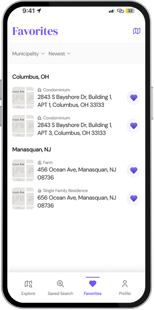
- Individual users can research property values and ownership, track favorites with alerts, and access data that was once difficult to find.
By combining cloud-based data management with intuitive GIS tools, PropertyPilot brings clarity and speed to property research, empowering professionals and consumers alike to make smarter, faster decisions. Its map-based interface simplifies complex datasets, giving users clear insights at the state, county, municipal, and parcel levels. Built for mobility, the platform allows data, documents, and images to be uploaded, shared, and managed from any device, whether in the office or in the field.
Our Approach
Methodology
Discovery Phase:
- Stakeholder interviews with GovPilot leadership to define MVP scope
- Competitive analysis of PropStream, Landglide, Zillow, and similar platforms
- UX audit of existing wireframes and user flow documentation
Design Phase:
- Mobile-first responsive design approach
- WCAG accessibility compliance integration
- Freemium user journey mapping with strategic limitation points
- Prototype development in Figma with clickable workflows
Implementation Strategy:
- AWS-hosted scalable architecture
- Google Maps integration for GIS mapping capabilities
- AWS OpenAI integration for natural language processing
- Phased rollout: Discovery → Design → Frontend Build → GIS/AI Integration → QA → Internal Launch
The Solution
Solution Architecture
- Data Layer: centralized 170M property records
- AI Layer: natural language query translation
- Interface Layer: React web + native mobile apps
- Infrastructure: AWS for scalability and <2s latency
Key Features
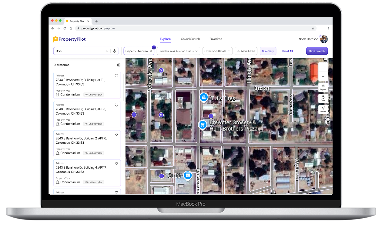
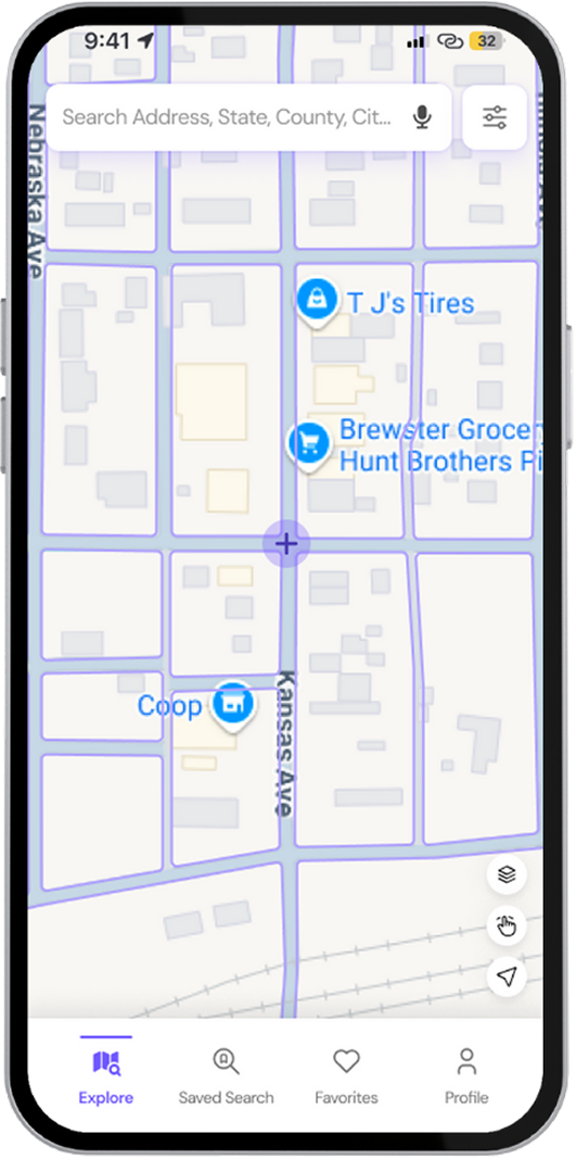
- Interactive GIS map with parcel overlays, zoning boundaries, draw-to-filter
- AI-powered natural language search with cached results and filter fallback
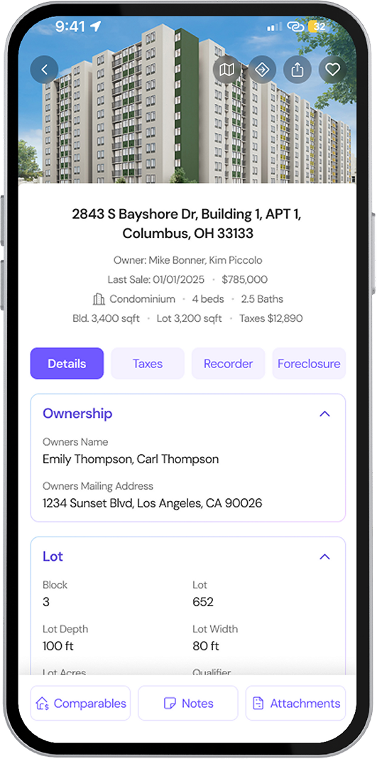
- Property profiles with ownership, assessments, comparables, foreclosure info
- Workspaces for saved searches, notes, attachments, and notifications
- Cross-platform access with synchronized data
Freemium Design
- Free tier: basic search, limited property views
- Premium tier: foreclosure data, saved searches, owner name, expanded features
- Upgrade prompts triggered at ~15% limitation threshold
Business Impact Targets
- DAU/MAU Ratio ≥ 20%
- Average session duration > 3 minutes
- Freemium limit hit rate ≥ 15%
- Upgrade CTR ≥ 5%
- 90% of queries with <2s response
Conclusion & Roadmap
PropertyPilot represents GovPilot’s expansion into the commercial real estate data market. The MVP provides a foundation for scalability, monetization, and future feature sets. Through this solution, they’re able to:
- Eliminate the need to search multiple databases and manually compile information
- Replace clunky government portals with modern, responsive interfaces
- Reduce property research time from hours to seconds
- Provide mobile-first access for field professionals
The long-term vision is to become the primary property data platform supporting professionals, governments, and consumers with real-time, accessible, and predictive real estate intelligence.


