The Challenge
Real estate professionals were forced to navigate a fragmented landscape of multiple county databases and outdated government portals that lacked reliable visual search tools. This inefficient workflow meant that essential property research often took hours instead of seconds. The industry lacked mobile-first tools, leaving field professionals without access to real-time insights while on-site.
Solution Implemented
Valere worked with their team to build a cloud-native platform hosted on AWS, integrating Mapbox for advanced GIS mapping and AWS OpenAI for natural language search capabilities. The solution features a responsive React-based web application and native mobile apps, ensuring synchronized data access across all devices. By implementing a freemium SaaS model with strategic feature limitations, Valere provided a scalable foundation for user acquisition and monetization.

About the Company
Mission
PropertyPilot was founded to improve the efficiency and performance of government, banking, and real estate organizations through an affordable, scalable SaaS platform. As an extension of GovPilot, PropertyPilot brings principles of accountability, automation, and accessibility to the broader commercial market. The platform serves as a single, reliable source of property information by aggregating assessment, ownership, and historical sales data across millions of parcels.
Key Leadership
The leadership team sought a partner capable of extending their established government data foundation into a high-performance commercial tool. Their vision was to eliminate the manual compilation of data and replace “user-hostile” interfaces with a modern, mobile-ready experience that supports real-time collaboration in secure environments.
The Challenge: Developing an AI-Powered Real Estate Platform to solve fragmented, manual data bottlenecks
Accessing real estate data today requires navigating multiple county databases, outdated interfaces, and fragmented sources. Professionals waste hours cross-referencing incomplete datasets, while consumers struggle to find basic property information through user-hostile government portals. The industry lacks a unified solution that combines comprehensive data coverage with modern user experience.
The lack of a unified solution resulted in operational bottlenecks and fragmented decision-making; professionals wasted hours manually compiling property research and due diligence reports. This inefficiency slowed down investment spotting, property valuations, and risk assessments for banks and insurers.
Why PropertyPilot Partnered with Valere for AI Native Solution Development
PropertyPilot partnered with Valere because the vision required more than traditional software engineering. As an AWS partner specializing in AI-native architecture, Valere was equipped to design a scalable cloud architecture, implement natural language search across massive property datasets, and deliver modern web and mobile experiences. Just as importantly, the team could ensure high performance at national scale while supporting a freemium SaaS growth model.
The Solution: Building an AI-Powered Search Platform with Cloud-Native Architecture to Unify Fragmented Real Estate Data Nationwide.
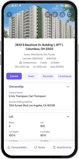
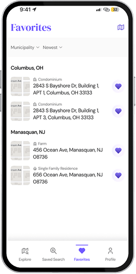
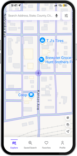
Valere built a scalable, AI-native architecture designed to handle 170M+ property records with sub-two-second latency. The platform simplifies complex datasets through a map-based interface, giving users clear insights at the state, county, municipal, and parcel levels. By combining cloud-based management with intuitive GIS tools, PropertyPilot empowers everyone from individual consumers to large-scale lenders to make smarter, faster real estate decisions.
Valere architected a high-performance environment purpose-built for massive data retrieval:
- Cloud Foundation: AWS-hosted cloud-native platform for maximum scalability.
- Frontend: React-based responsive web application and native mobile apps.
- AI Layer: AWS OpenAI integration to translate natural language queries into data filters.
- Mapping: Mapbox and Google Maps integration for interactive GIS overlays and zoning boundaries.
The implementation followed a structured, phased approach to reduce risk and accelerate delivery. During Discovery, the team conducted stakeholder interviews and competitive analysis to clarify user needs, business goals, and differentiation opportunities. In the Design phase, mobile-first UI/UX prototypes were developed in Figma with full WCAG compliance to ensure accessibility and usability from day one.
Build focused on frontend development and core backend architecture, establishing a scalable foundation for future enhancements. GIS capabilities were then integrated with AI-powered natural language processing to enable intuitive, map-based querying and intelligent data interpretation. The engagement concluded with rigorous internal QA testing and a phased production rollout to ensure performance stability and a smooth transition to live environments.
The Results
The implementation of PropertyPilot transformed property research from a manual chore into a high-speed, AI-driven experience, providing nationwide coverage with elite performance.
Key Outcomes
Technical Performance:
- Achieved nationwide coverage of 170M+ property parcels.
- Sub-2s latency for 90% of all data queries.
- Seamless data synchronization across web and mobile platforms.
Efficiency & Workflow Gains:
- Reduced property research time from hours to seconds.
- Eliminated the need to manually cross-reference multiple county databases.
- Enabled real-time field data management and image uploads from any device.
Business Impact Targets:
- 20% DAU/MAU ratio targeted for user engagement.
- 15% freemium hit rate and 5% upgrade CTR targets to drive SaaS revenue.
- Average session duration target of >3 minutes.